


Green Map System (GMS)
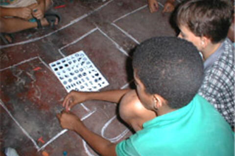
GMS uses information and communication technology (ICT) to promote sustainability and community participation in the local natural and built environment through the locally-led making and sharing of maps and mapping techniques. Through its interactive website, GMS offers adaptable mapmaking tools and a shared visual language in the form of a set of 170 universal icons and adaptable mapmaking tools representing different kinds of green sites and cultural resources. This language and these tools took shape, over the development of the initiative, in a collaborative, "open source" manner, as participants mentored one another and shared their experiences in an effort to guide local project leaders in the creation of environmental and cultural maps. While the language is global - mapmakers have translated the Icons into Spanish, French, Japanese, German, Portuguese, Chinese, Arabic, and Indonesian, with others in progress - mapmakers are invited into a diverse online community that provides ideas for creating "regionally flavored images that fulfill local needs". Among the specific tools offered are:
- Tools for youth, community, and professional Green Map projects
- The Open Green Map interactive mapmaking and exploring platform
- Green Map Impacts book
- Green Map mobile website - type GreenMap.org into any phone's internet browser for sites charted on the Open Green Map
- Green Map iPhone App
Participation and local initiative is key to what organisers describe as GMS's "direct, democratic communication, dependent on local knowledge, action and responsibility." For this reason, GMS does not present a formula or set guide for mapmaking. Each group (of varied size) determines how their Green Map will look and what its format will be; some maps are high tech and use geographic information systems (GIS), while others are low tech and hand-drawn. Organisers estimate that a first Green Map might take 6 to 10 months to complete, though some have taken years. The mapmaking team owns the Green Map they have created, which they can sell or distribute in the way that best fulfills the project's goals and local needs. The new Open Green Map makes it much faster and cheaper to publish online.
Youth participation in collaborative mapmaking is fostered through a dedicated section of the GMS website. The idea is that creating neighbourhood-scale Green Maps might help young people sharpen their powers of observation as they learn about the community and ecology around their home or school. Narrative text, background information, photos, drawings, and poems might form part of youth Green Maps. In an effort to support environmental education, free mapping modules are designed to be used by young people and their teachers, in school or after school; educator resources are also offered.
Environment, Technology.
GMS is a not-for-profit organisation active since 1995. As of February 2010, GMS is active in approximately 635 locations in more than 55 countries around the world.
GMS website, accessed October 11 2005 and February 16 2010; and emails from Té Baybute and Wendy Brawer to The Communication Initiative on February 17 2010 and February 26 2010, respectively.
- Log in to post comments